FIRST ALERT FORECAST: Enjoy Wednesday. After that, it’s getting cold!
FIRST ALERTING YOU TO...
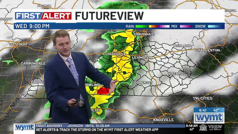
Rain Arriving Wednesday Evening, System Strengthens
First Snow Flakes of the Season Possible Friday
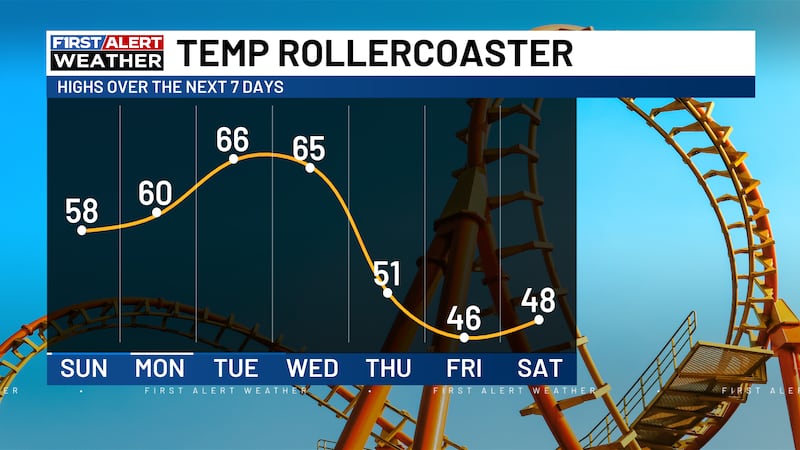
Dramatic Pattern Shift: 70s to 40s in 48 Hours
One More Pleasant Night, Then Major Changes Arrive Wednesday
Eastern Kentucky is in for one more pleasant evening before a significant weather system crashes the party. Tonight brings clear skies and mild temperatures, but by Wednesday evening, rain moves in, and by Friday, we could see the first snowflakes of the season.
Tonight: Clear Skies, Mild Lows
Tonight will be pleasant with clear skies and lows dipping into the mid-40s. There may be some patchy fog developing along rivers and larger creeks, especially late at night, but nothing that will cause major issues. The ridge of high pressure that has been keeping us dry and pleasant is still firmly in control. Light winds and dry air make for ideal conditions for a comfortable evening.
Wednesday: The Calm Before the Storm
Wednesday starts off pleasant with mostly sunny skies and highs in the low 70s, still above normal for mid-November. But here is where you need to pay attention: as the afternoon progresses, clouds will increase. By evening, a potent shortwave trough diving out of the Upper Midwest will carve out a deep, anomalous trough over the eastern U.S. This is the setup for our weather to change dramatically.
Wednesday Evening Into Thursday: System Arrives, Rain Breaks Out
Rain is expected to break out Wednesday evening as a cold front sweeps across Eastern Kentucky late Wednesday night into early Thursday morning. This is not a wimpy system. It is a significant weather event that will bring scattered to widespread rain. Temperatures Thursday will follow an unusual pattern. Since the cold front passes through during the morning hours, daytime highs may actually be reached around or shortly after daybreak, followed by falling or steady temperatures through the afternoon as cold air moves in. Expect highs in the low 50s across the region, with upper 50s in the Big Sandy areas. By Thursday night, lows drop into the low to mid-30s.
Friday: The Big Story, First Snow Possible
This is where it gets really interesting. The upper trough deepens and strengthens overhead Friday, pushing atmospheric heights below the 5th climatological percentile. That is extremely cold air. A brisk Canadian air mass moves in on breezy northwest winds. Highs Friday struggle to climb out of the 40s, and here is the key: lingering post-frontal and upslope showers could mix with or transition to the first flurries of the season across the higher terrain of southeast Kentucky Thursday night into Friday, and again Friday night.
So yes, we could see the first snowflakes of the season, but they will be confined to higher elevations. This is not a major snow event. Think flurries and light accumulations at best in the highest areas. But for those at elevation, Friday morning and Friday night are worth monitoring.
Saturday: Still Cold
Saturday continues the cold pattern with highs still in the 40s and overnight lows in the mid to upper 20s. The system will be pulling away, but the cold air lingers.
Sunday Through Tuesday: Recovery and Warming
A high-amplitude ridge builds across the region Sunday through Tuesday, bringing surface high pressure, dry weather, and fair skies. Temperatures gradually recover each day. Sunday highs reach the low 50s, warming to the upper 50s and low 60s by Tuesday. Overnight lows remain at or slightly below freezing. It is a nice recovery pattern after the cold snap.
Stay Weather Ready
This is a pattern with significant changes, so download the WYMT First Alert Weather App and keep checking WYMT First Alert WeatherNOW for updates. We will be tracking the timing of rain Wednesday evening, the potential for that Friday snow transition, and any impacts to your commute and travel plans.
Copyright 2026 WYMT. All rights reserved.